For each hub, the mission began with a shared diagnostic phase, including an inventory of public transportation, multimodal traffic counts, parking surveys, and landscape analysis.
From these findings, three possible development scenarios were collaboratively developed during workshops with local authorities, municipal departments, and stakeholders. The selected plan was developed into two operational mobility hub agreements, organised into phases and with budget estimates.
To supplement these papers, we included scaled-down diagrams at a ratio of 1:1000. We also proposed an administrative structure that designates leadership, funding sources, and management strategies for the project.
Study context and objectives
The study of Bondy station’s mobility hub is part of the “Les places du Grand Paris” (Places of Greater Paris) master plan developed by SGP for all 65 Grand Paris Express stations (200 km of automated metro), in accordance with the Île-de-France Urban Mobility Plan. This master plan aims to create top-quality multimodal transfer areas around future Grand Paris Express stations. Bondy station is located in an area of dense urban development characterized by a north-south divide created by railways and highways, with growing and heavy traffic. The study aimed to provide concrete support for the principles validated by Île-de-France Mobilité principles in 2014 – station location, modes of access, urban integration – by enriching the SGP’s preliminary studies with a broader approach to intermodality and public spaces. It also aided in the creation of a blueprint and the standardization of the prerequisites for the final pre-project documents for the TZen 3 BRT.
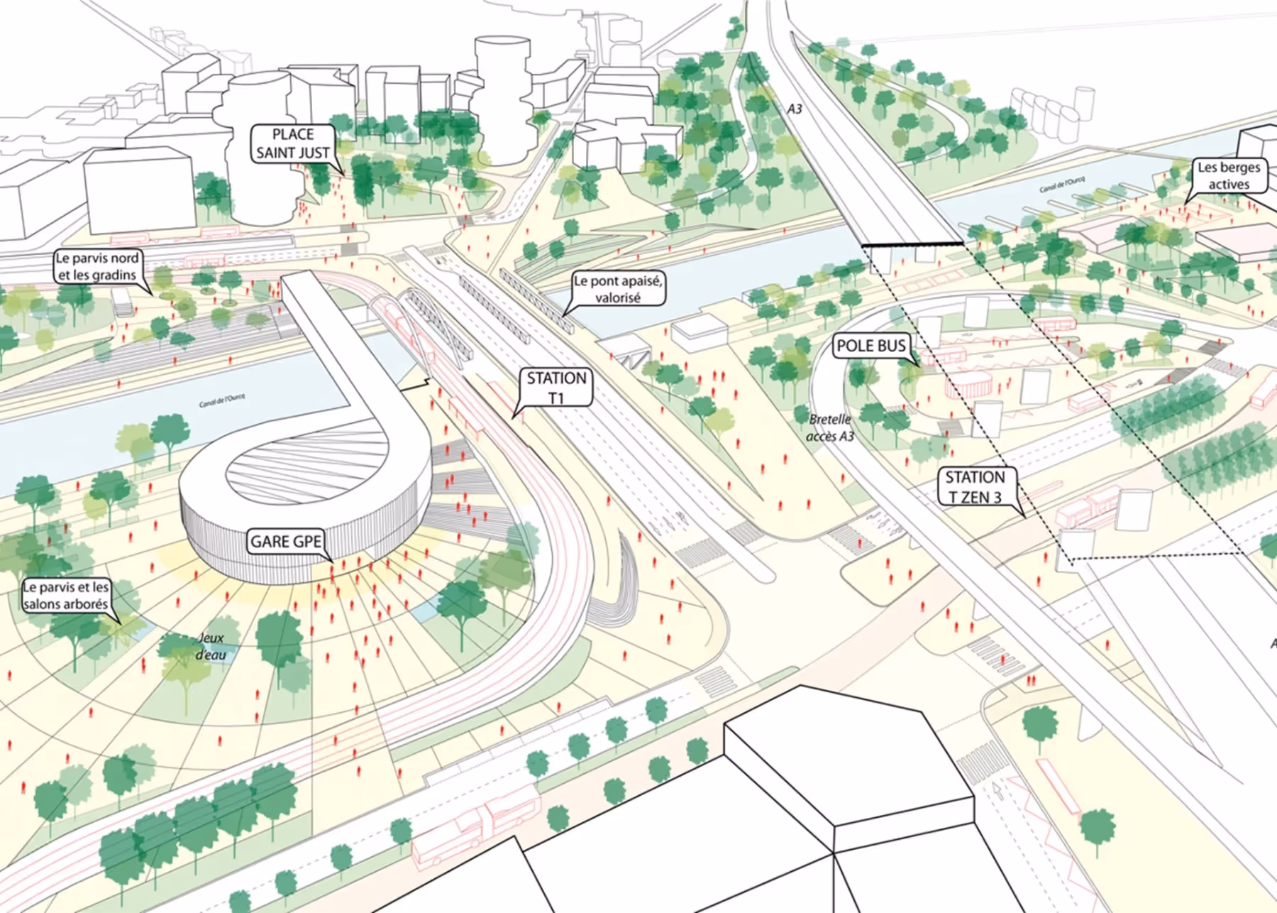
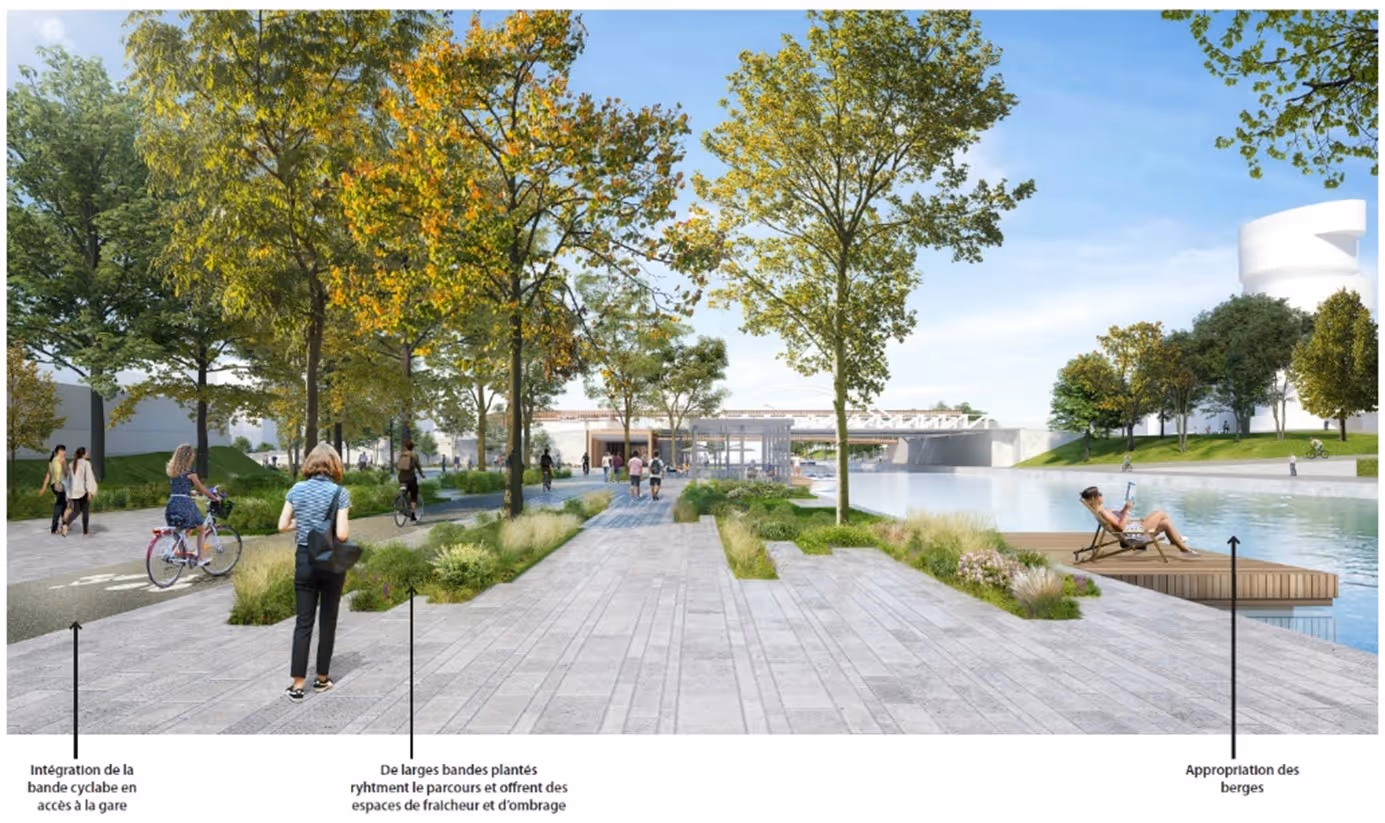
The Pont de Bondy hub, meanwhile, is located beneath the A3 and A86 highway viaducts, at the junction of three municipalities, opposite the Ourcq Canal, and adjacent to the Tzen 3 and Tramway T1 modernisation projects. The goal was to reimagine this once car-centric area as a true metropolitan plaza, fostering interconnectivity among various modes of transportation, prioritizing pedestrians and cyclists, and enhancing the overall landscape along the waterfront. Furthermore, the study of the Pont de Bondy hub was instrumental in the development of the initial drafts of the TZen 3 project, offering valuable insights for the subsequent project phase documentation.
Challenges encountered
Technical
On each of the two sites, the consortium had to work with heavy infrastructure, such as highways, viaducts, and rail lines. This caused usage conflicts and congestion at key intersections. Six multimodal traffic counts and five parking surveys supported capacity modelling and signal timing plans. These were designed to ensure the continuity of transit services without overloading secondary roads.
Environmental
Landscape analysis and noise measurements revealed that noise and air pollution levels exceeded regulatory limits, particularly in school and residential areas. The recommendations therefore included the creation of green corridors, the improvement of areas under the viaducts, and the implementation of low-impact urban logistics (such as off-peak deliveries and park-and-ride systems) to reduce nuisances and improve the quality of life.
Transamo’s mandates
The consortium structured each study into three complementary phases. The first phase, known as the shared diagnostic phase, involved six multimodal counts and five rotation-occupation surveys to accurately measure road, pedestrian, cyclist and rail flows, supplemented by a landscape analysis and workshops to validate the issues at stake. The next phase involved developing two or three development options for each site: roads, forecourts, public spaces and park-and-ride facilities, before comparing them in multi-criteria workshops attended by elected representatives, SGP technicians and user associations. Each of the options was assessed in terms of its operation, its impact on accessibility, its estimated cost, and its social acceptability. Finally, two hub contracts were drawn up to formalise the chosen scenario with: more than 50 phased and costed action sheets, plans of intent on a scale of 1:1,000, a detailed financial package and timetable, and a partnership governance plan for the hub projects (prime contractor, funders, managers).
Governance
The double study of Bondy RER station and Pont de Bondy hubs is part of a larger initiative by local authorities to prepare for future Grand Paris Express stations. Financed by SGP, the work was carried out by Est Ensemble, which contracted the Gautier Conquet-Transamo consortium, with support from CDVia. The steering committees, which consisted of SGP, Est Ensemble, the Seine-Saint-Denis department, and the municipalities of Bondy, Bobigny, and Noisy-le-Sec, established the general direction and approved each project phase. The monthly technical committee, which included RATP, SNCF, Sequano, and the engineering teams for the Grand Paris Express and Tzen 3, ensured operational coordination.
Territorial impacts
The implementation of the mobility hubs will improve the links between RER E, Tramway T1, Tzen 3, and the local bus network. It will also ensure safe access for pedestrians and cyclists near roads and railways. Transforming neglected areas beneath viaducts into more inviting landscapes, as well as designing integrated parking lots, can significantly improve the quality of life in cities. These initiatives can reduce noise levels, decrease air pollution, increase urban appeal, and stimulate economic growth.
Key figures
- Six multimodal traffic counts.
- Five parking surveys.
- Two to three development scenarios per hub.
- More than twenty detailed and budgeted action plans.
Key takeaways
This research emphasizes the proficiency of Transamo in handling intricate initiatives. It showcases their competence in diverse areas of transportation analysis, including extensive multi-source evaluation, traffic simulation, joint development of functional and strategic plans, outline designs, negotiation of facility operation contracts, and establishment of governing structures.
Frequently asked questions (FAQ)
What is a multimodal transit hub?
A multimodal transit hub s a location that concentrates and facilitates transfers between different modes of transportation. It typically centres around a main transit line. It offers facilities such as platforms, stops, bike parking, and taxi ranks, as well as services like ticketing and passenger information. Additionally, it provides amenities like safe walkways and waiting areas.
What is a multi-criteria workshop ?
It is a meeting where stakeholders (elected officials, technicians and users) compare several options (development scenarios) across different criteria (cost, feasibility, impact, and acceptability) to choose the best solution.
What is a mobility hub agreement?
It is a formal document that outlines the chosen scenario, including detailed plans, budgets, and timelines. It also establishes a steering committee and a technical committee to oversee the project’s progress and accountability.
Share your experiences
Does your organization face similar challenges? We’re eager to hear about the strategies you are implementing. The Transamo Canada team is always ready to connect, learn more about your initiatives, and offer our experience.
Contact us at contact_transamo.canada@transamo.com